back to guidebook home page
Cross Vermont Trail Maps
Explore trails, parks and communities across Vermont, following the Wells River and the Winooski River. Cross Vermont Trail is a project to build a new trail spanning the state from the Connecticut River to Lake Champlain.
Each map shows open sections of trail, and highlights roads that can be used to link them together to make longer trips. The route is shown in the context of an area street map to help you orient to the trail location. A "cue sheet" accompanies each map with brief turn by turn directions (both east to west and west to east).
The total route is a little over 90 miles long. About half of this is on trails, paths, old railbed and quiet country roads. But about half is still currently on larger roads. We are working to fix that!
- The statewide route is broken up into twelve maps. You can scroll through the maps and cue sheets below.
- Or you can download the printable maps and cue sheets all at once here. (PDF 12MB)
Temporary Route Notices ~ storm damage, road construction, you name it. Check here for updates on temporary changes or impacts to plan around along the Cross Vermont Trail route. Use this information in addition to the information in our maps and cue sheets.
Been out on the trail lately? Let us know what you saw. Would you like more of the route to be off road? You can help build more trail!
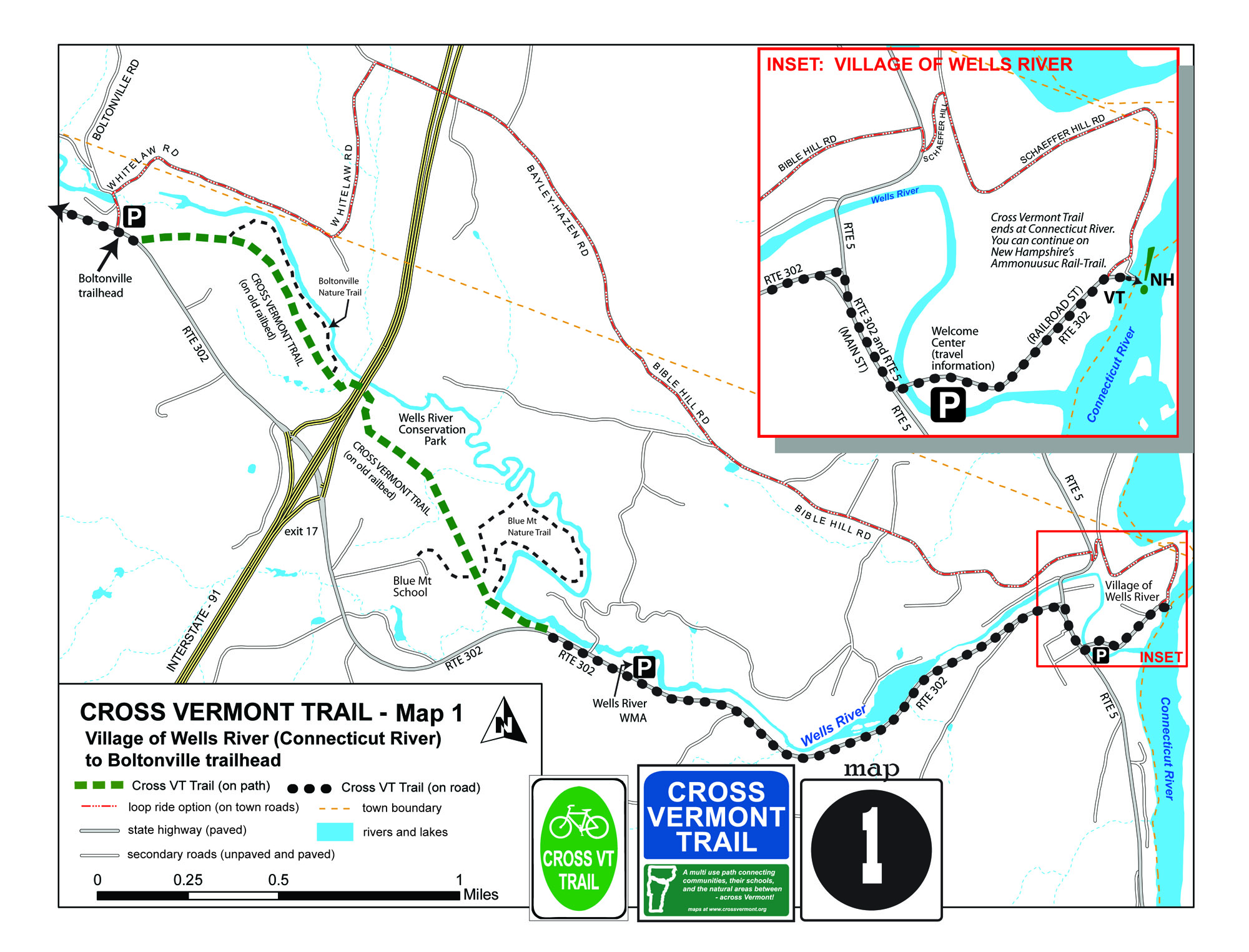
WELLS RIVER, NEWBURY
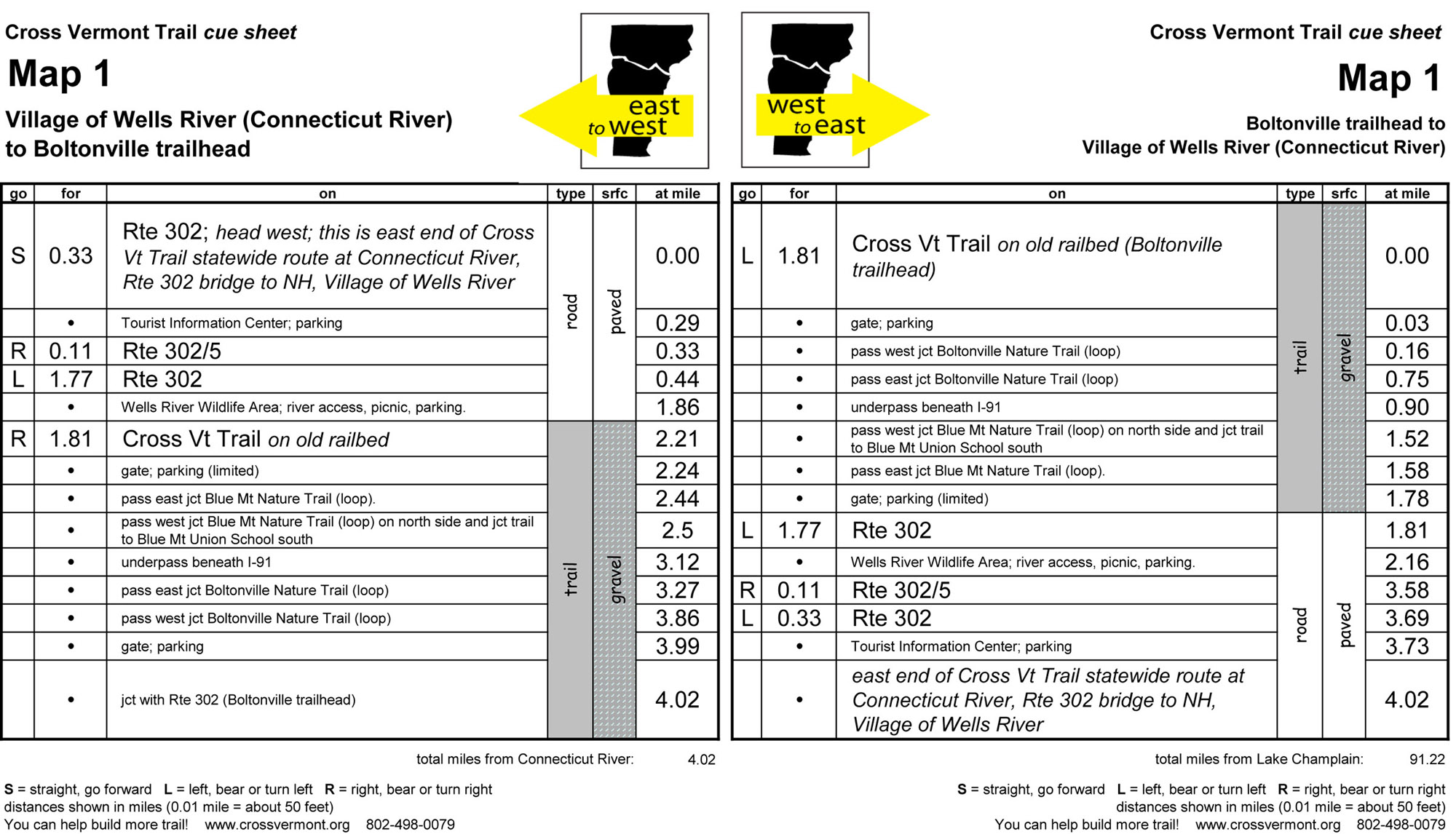
Map #1 Village of Wells River (Connecticut River) to Boltonville trailhead (4.02 miles)
- Trail on old railbed through Wells River Conservation Park and other preserved land along the Wells River.
- Several nature trail loops are connected together by the Cross Vermont Trail route.
- The trail underpass at I-91 was built by the Cross Vermont Trail Association in 2003.
- Village of Wells River pleasant place to start or end a journey.
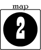
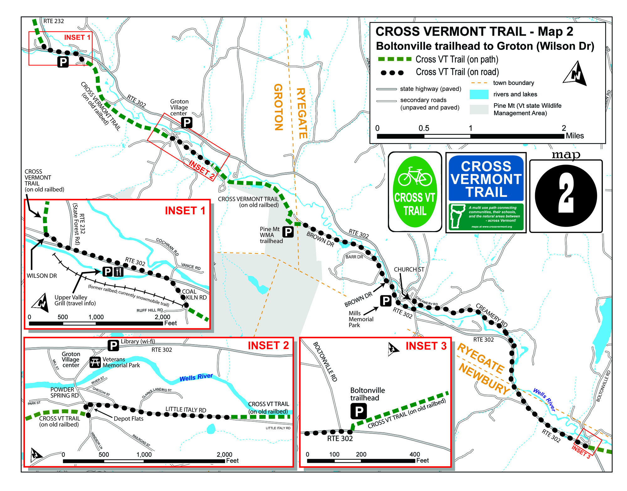
NEWBURY, RYEGATE, GROTON
Map #2 Boltonville trailhead to Groton (Wilson Dr) (8.39 miles)
- Peaceful village of South Ryegate.
- Meandering views of pastures with backdrop of forested hills.
- Long stretch of trail on old railbed (thank you to the Town of Groton!)
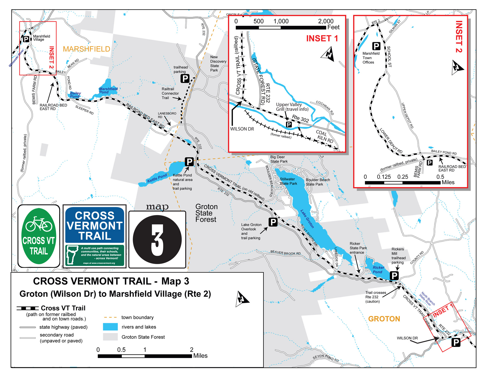
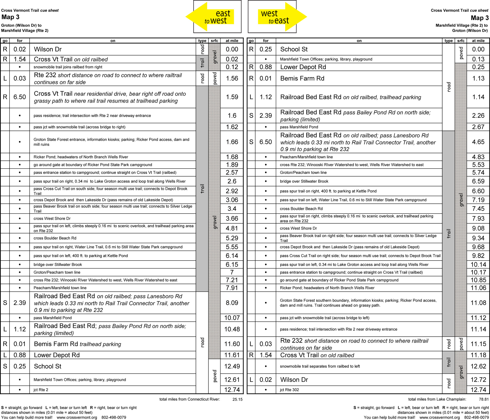
GROTON, MARSHFIELD
Map #3 Groton (Wilson Dr) to Marshfield Village (Rte 2) (12.74 miles)
- Continue long stretch of trail on old railbed.
- Groton State Forest, Vermont's second largest state forest.
- A string of lakes and ponds, with small, steep mountains providing dramatic backdrop.
- Several campgrounds. This is the part of the trail for a camping vacation.
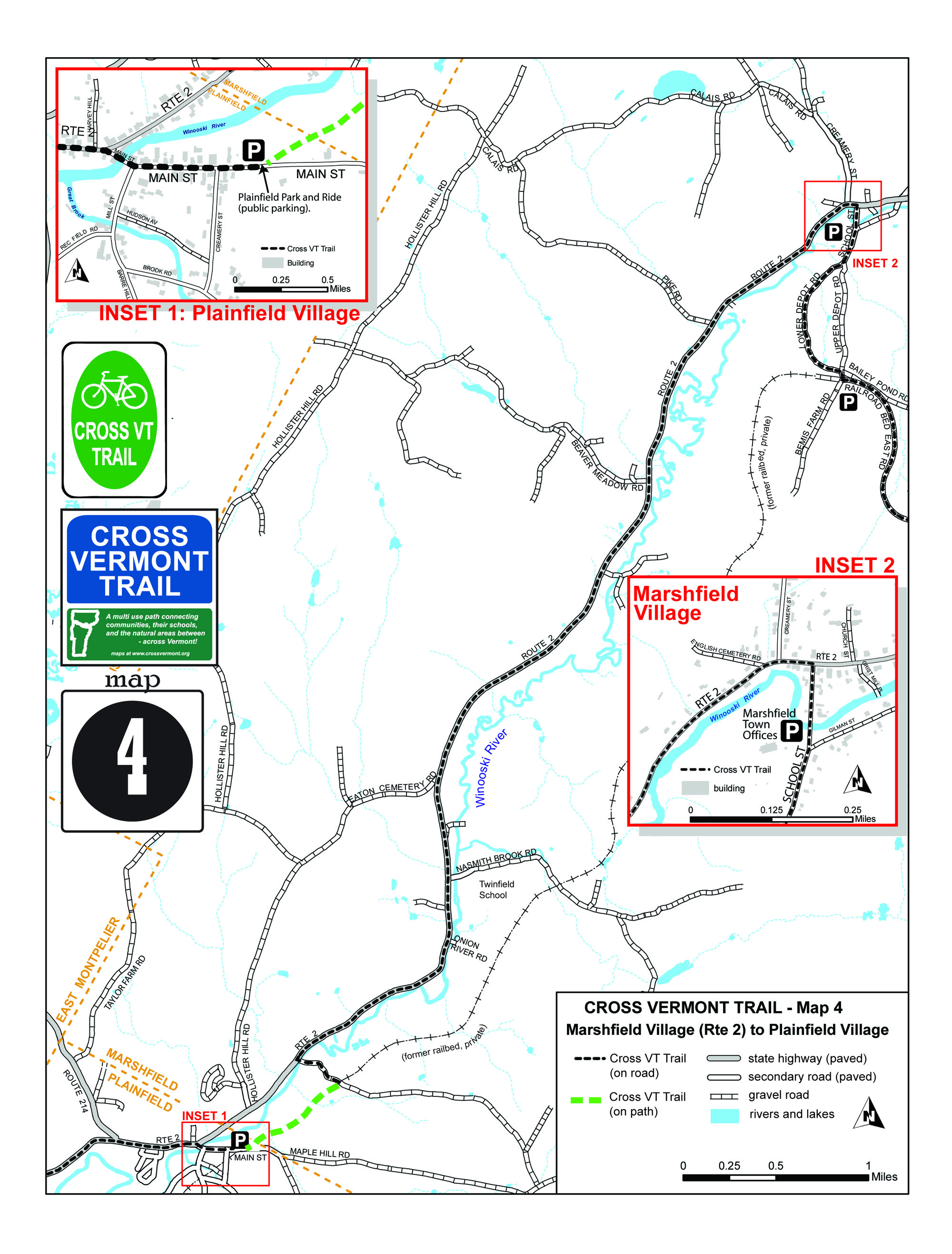
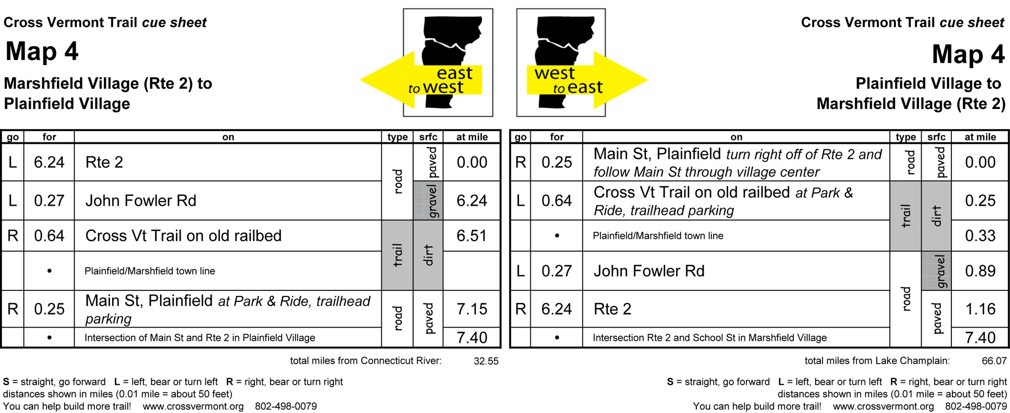
MARSHFIELD, PLAINFIELD
Map #4 Marshfield Village (Rte 2) to Plainfield Village (7.4 miles)
- The "village to village" route. One nice theme of the entire statewide route is the sequence of active village down towns.
- (More) rolling pastures and forested hills.
- A very cool timber frame covered bridge. (Town of Marshfield Martin Covered Bridge Park, to the side of Rte 2.)
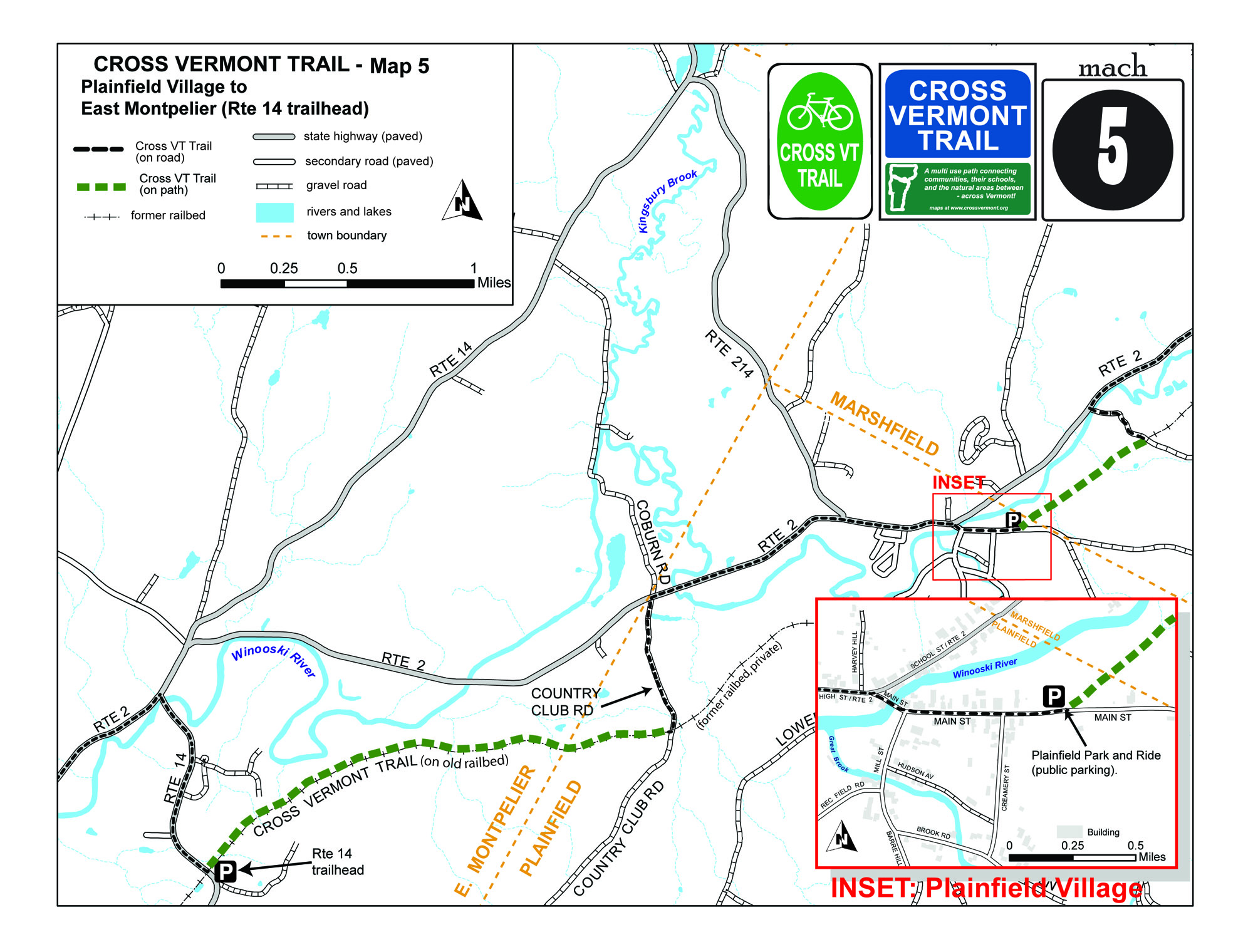
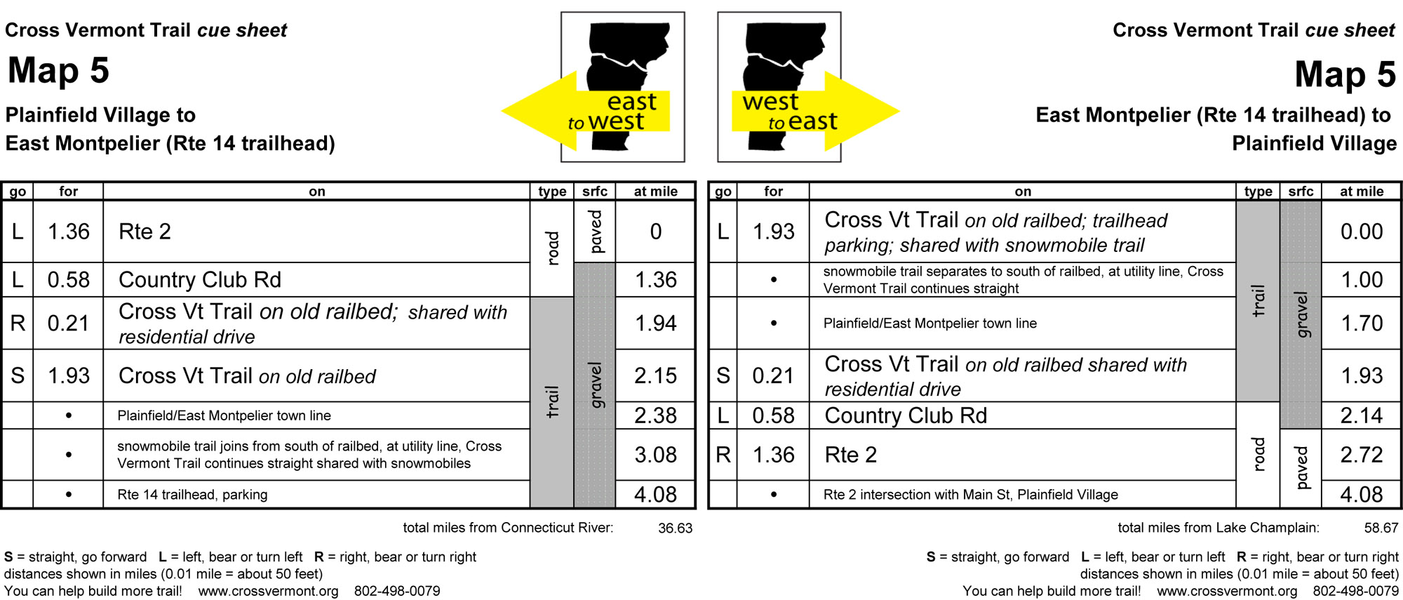
PLAINFIELD, EAST MONTPELIER
Map #5 Plainfield Village to East Montpelier (Rte 14 trailhead) (4.08 miles)
- The highlight here is a stretch of trail on the old Montpelier - Wells River Railroad between Country Club Rd and Rte 14. Once you start in from either end, it doesn't take long before you feel like you are deep in the woods. Thanks to efforts by several local trail groups, the towns of Plainfield and East Montpelier, and the generosity of land owners to make this trail available to the public.
- Along Rte 2 in Plainfield, the route is scenic, though at times the traffic can be heavy.
EAST MONTPELIER, MONTPELIER
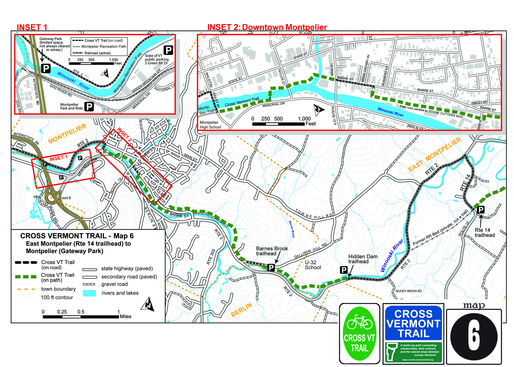
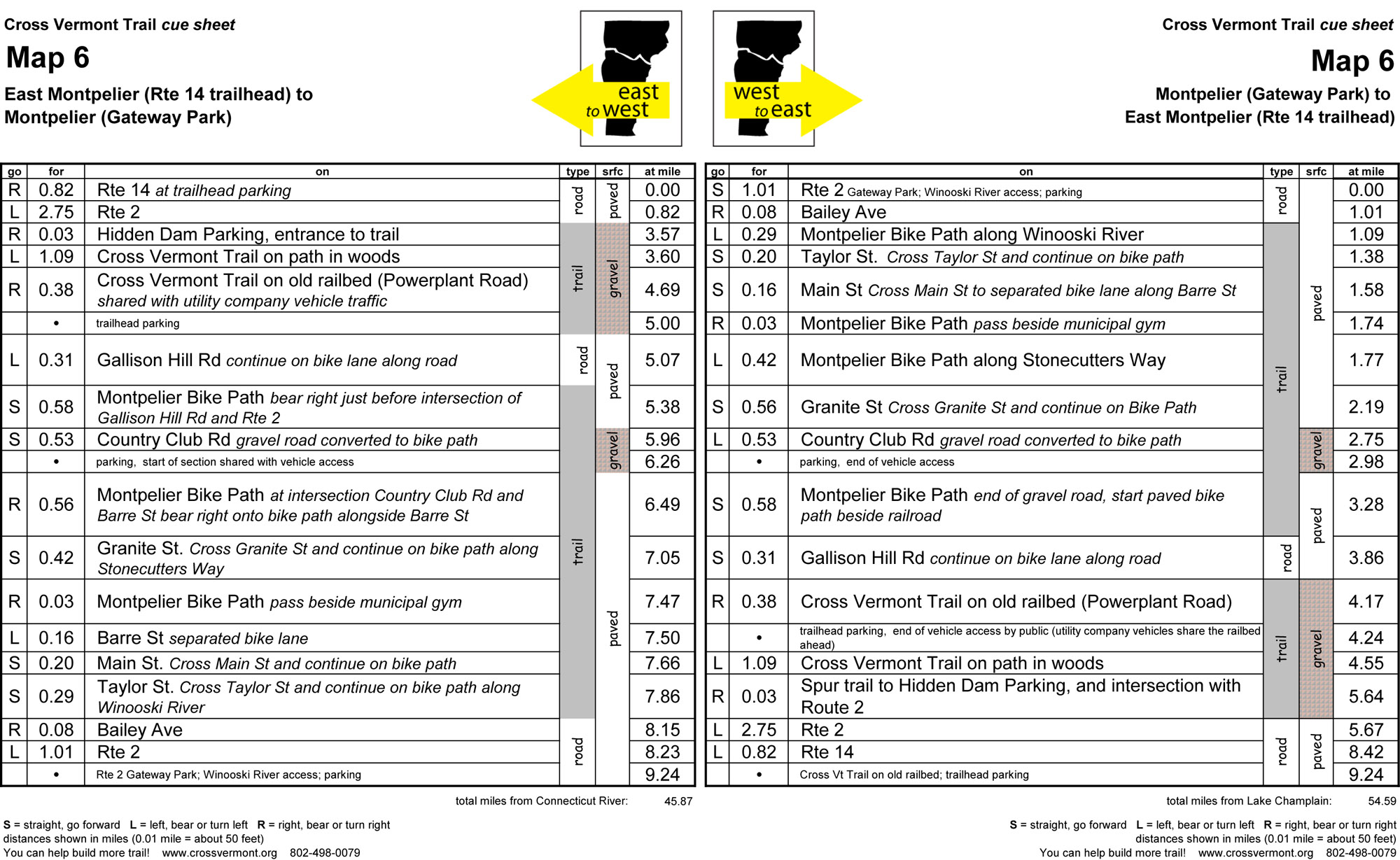
Map #6 East Montpelier (Rte 14 trailhead) to Montpelier (Gateway Park) (9.24 miles)
- Cross Vermont Trail Association is building an off road route for this section. Sections are being opened in phases as they are completed. Please call anytime if you would like to learn more about this effort. In the meantime, a portion of the the approach to Montpelier from the east is still on highways which are often congested, with high speed traffic.
- Once you get to Montpelier, though, a nice network of bike paths weave through the dynamic downtown area of Vermont's capitol city.
MONTPELIER, MIDDLESEX, BERLIN, MORETOWN
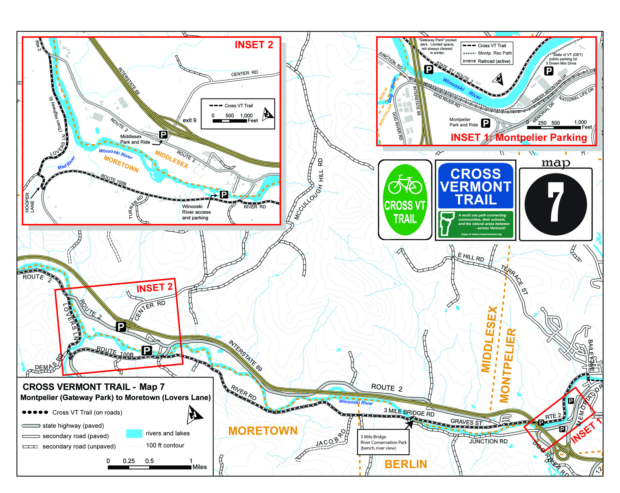
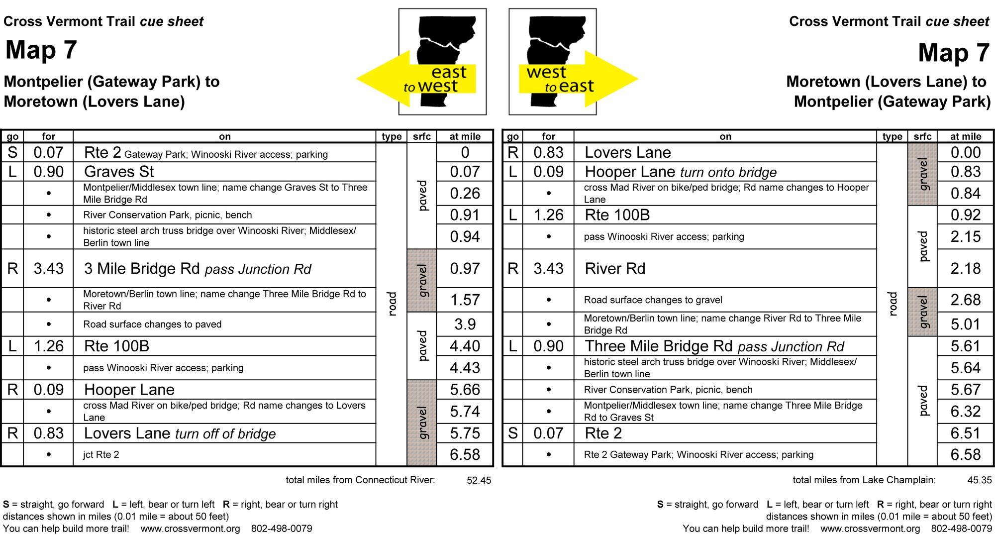
Map #7 Montpelier (Gateway Park) to Moretown (Lovers Lane) (6.58 miles)
- A good long stretch of pastoral dirt roads; past farms, along Winooski and Mad Rivers.
- Rte 100B is large road, but officially recognized as a scenic byway.
- Hooper Lane/Lovers Lane historic metal truss bridge over a dramatic gorge on Mad River.
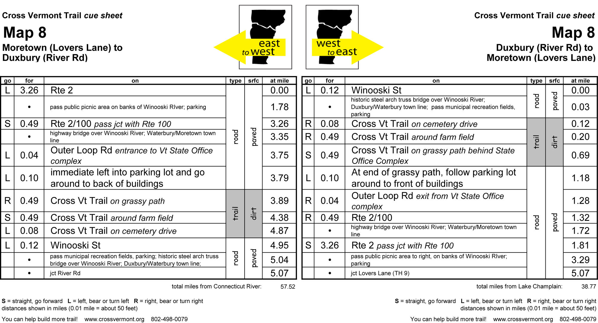
MORETOWN, WATERBURY, DUXBURY
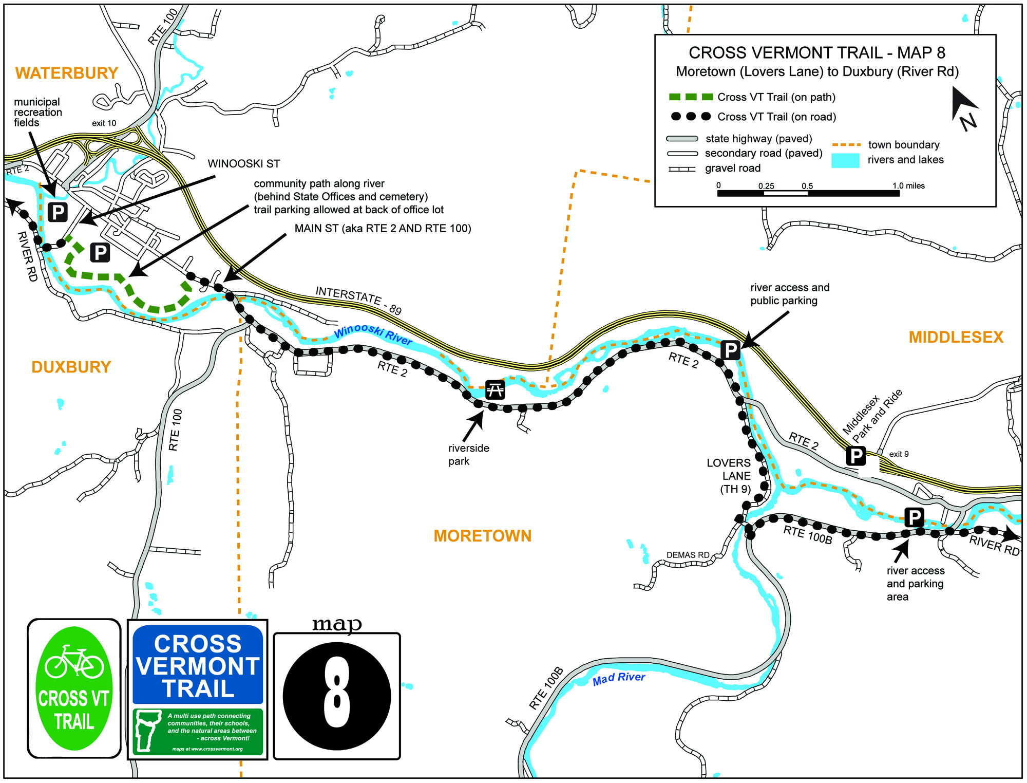
Map #8 Moretown (Lovers Lane) to Duxbury (River Rd) (5.07 miles)
- Rte 2 has some scenic moments along the Winooski River. (Though traffic can be heavy at times).
- Waterbury's greenway path along the Winooski, behind the State Office Complex.
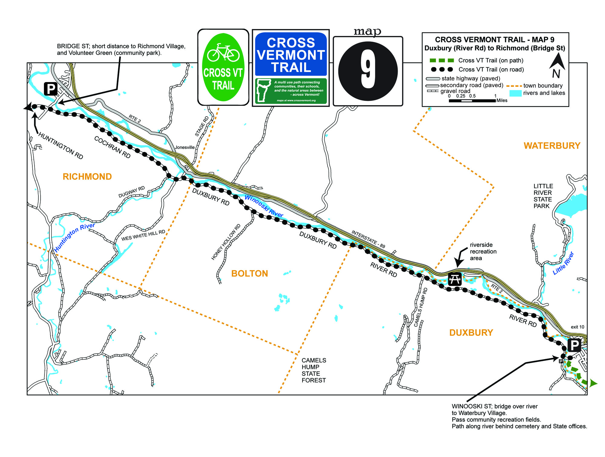
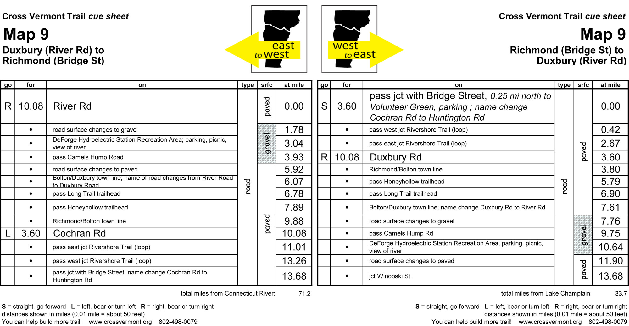
DUXBURY, BOLTON, RICHMOND
Map #9 Duxbury (River Rd) to Richmond (Bridge St) (13.68 miles)
- Another good long run on an old time Vermont dirt road; along Winooski River.
- Trailheads for Camels Hump State Park (Honey Hollow area, and Long Trail.)
- Tucked by the river, at a hydro dam, a small recreation area with a big view.
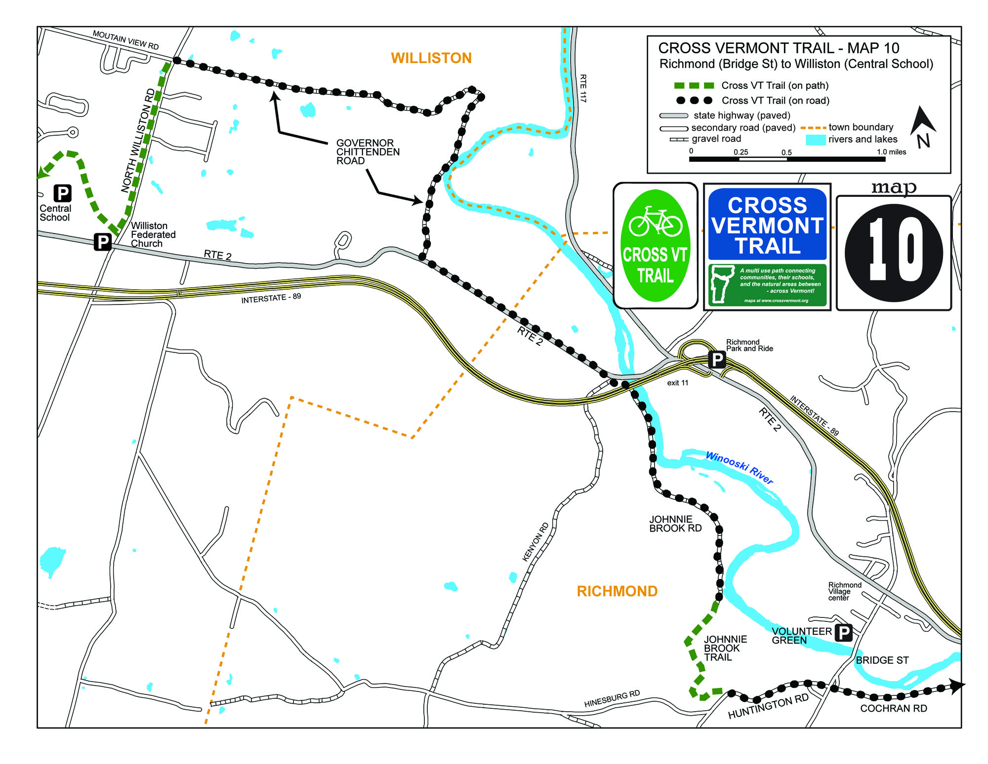
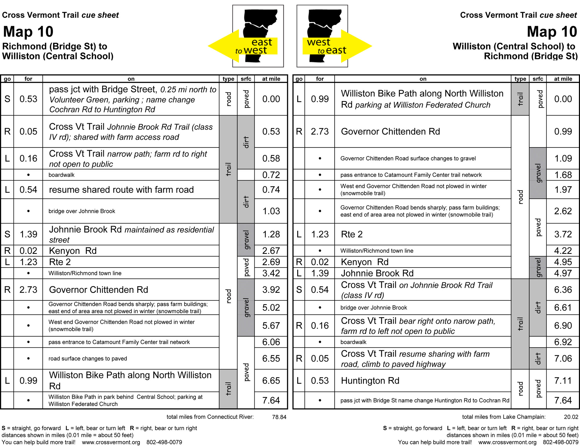
RICHMOND, WILLISTON
Map #10 Richmond (Bridge St) to Williston (Central School) (7.64 miles)
- Johnnie Brook Trail (on Class IV road), pleasant pastoral trail.
- Grand views across the farm fields to the mountains beyond.
- Many walking and mountain biking trails connect to the Cross Vt Trail route.
WILLISTON
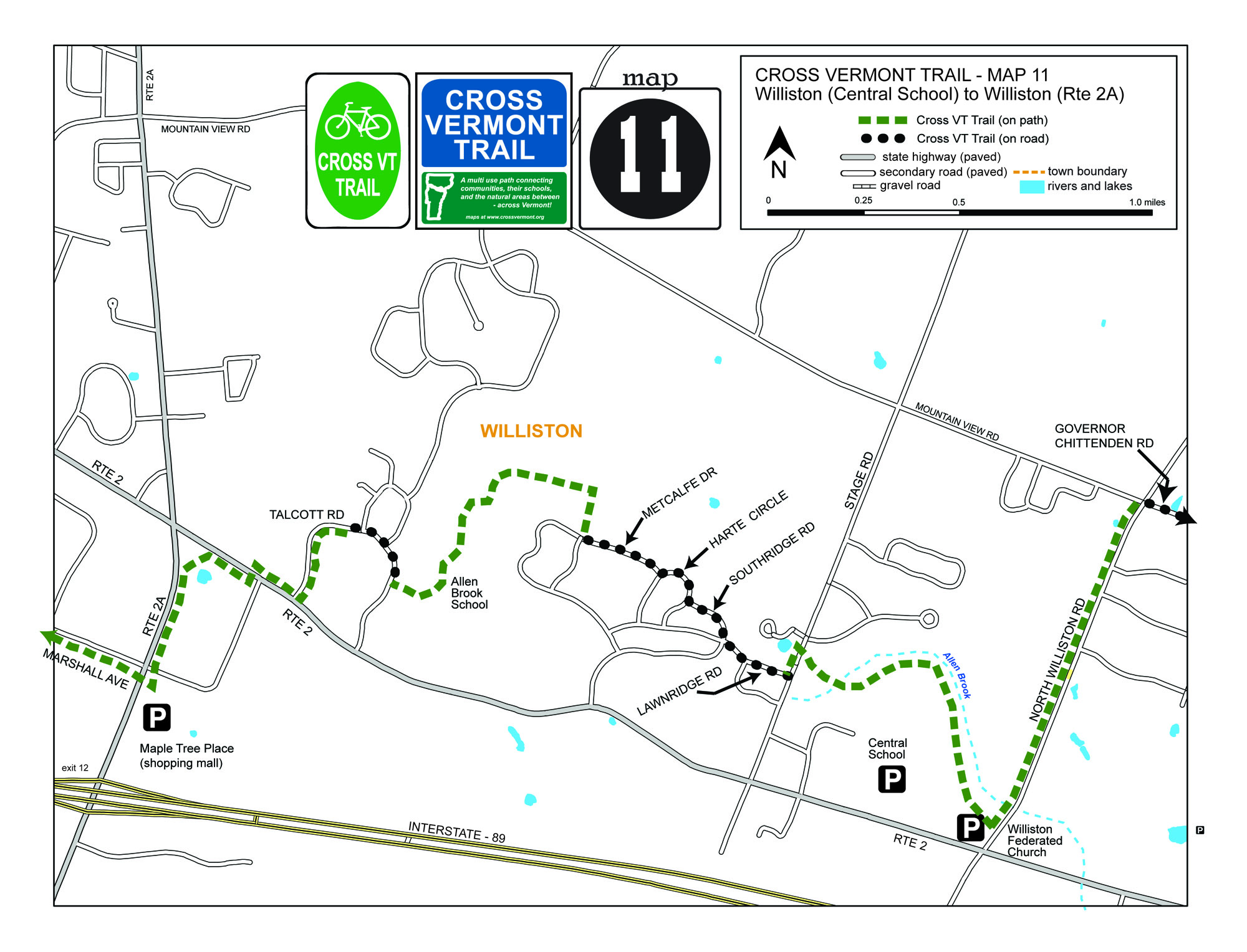
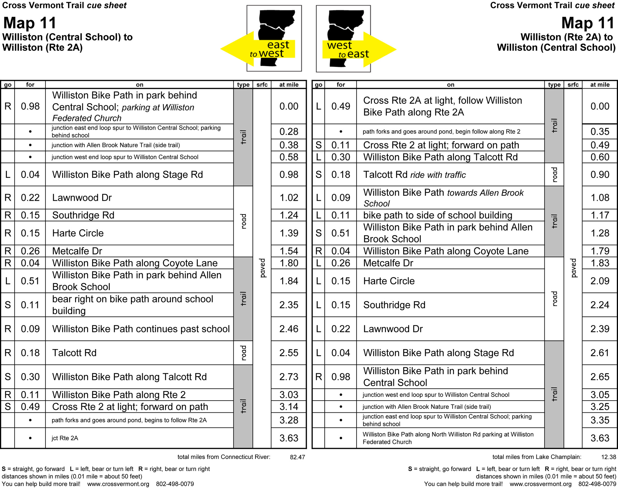
Map #11 Williston (Central School) to Williston (Rte 2A) (3.63 miles)
- Classic "neighborhood to school to shops" bike path network. Nice to see.
- Nature trails, a well, such as along Allen Brook.
WILLISTON, SOUTH BURLINGTON, BURLINGTON
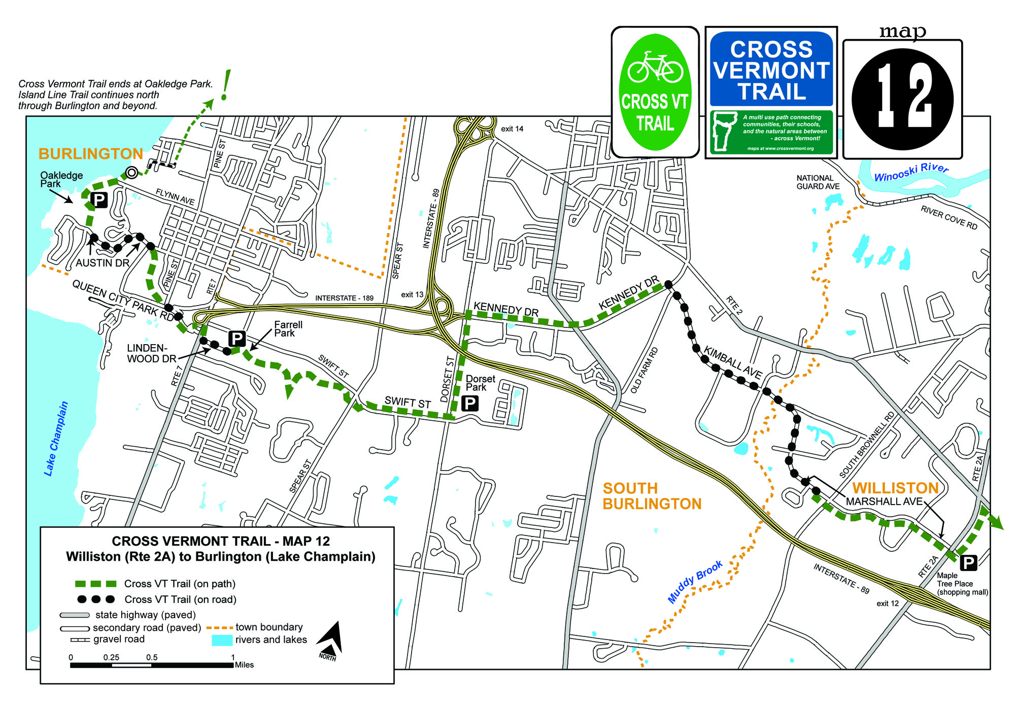
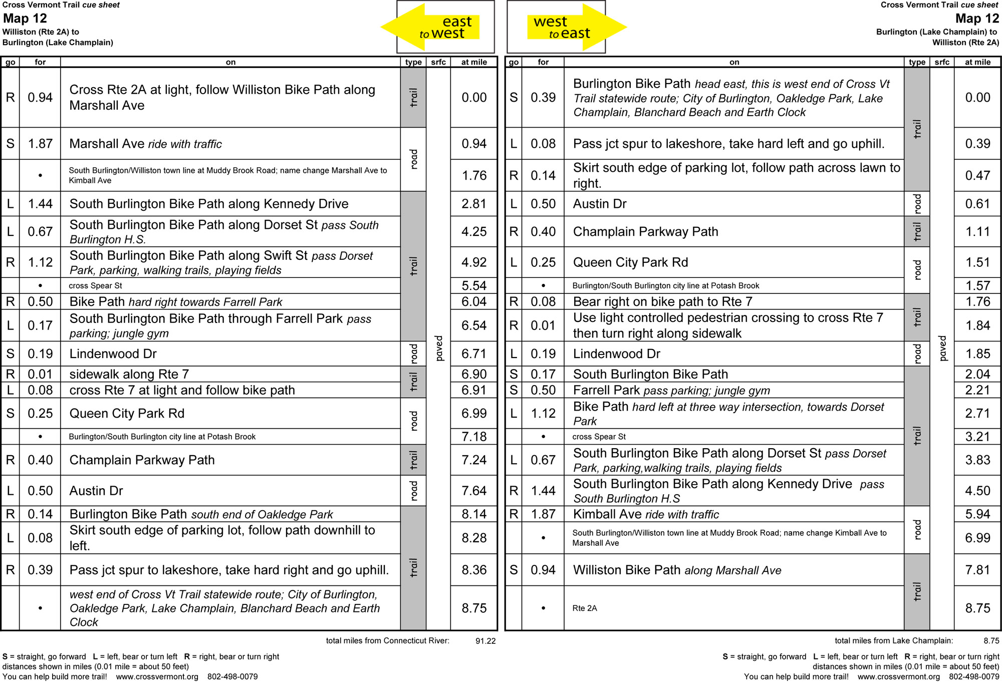
Map #12 Williston (Rte 2A) to Burlington (Lake Champlain) (8.75 miles)
- South Burlington has a great community path, connecting parks, schools, and neighborhoods; including some quiet natural areas.
- Burlington's Oakledge Park, Lake Champlain beaches, stone circle, and that's some treehouse.
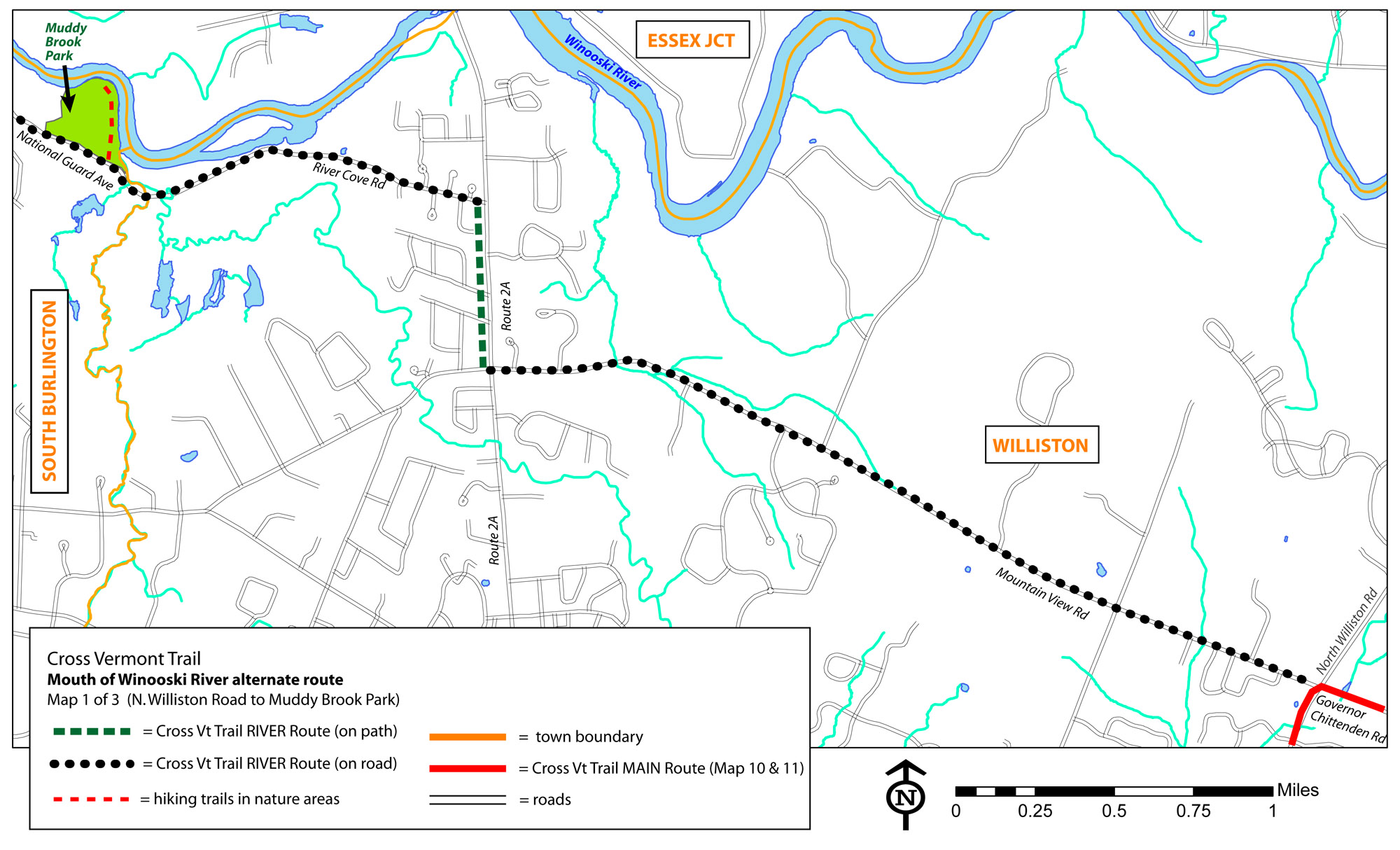
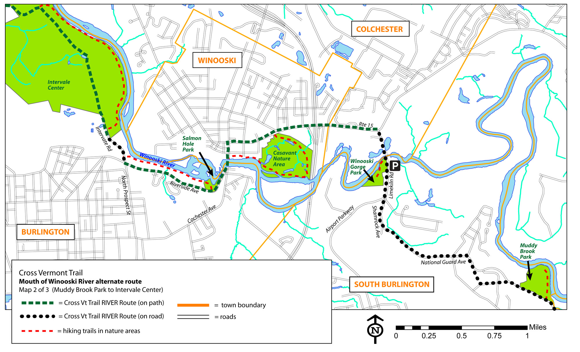
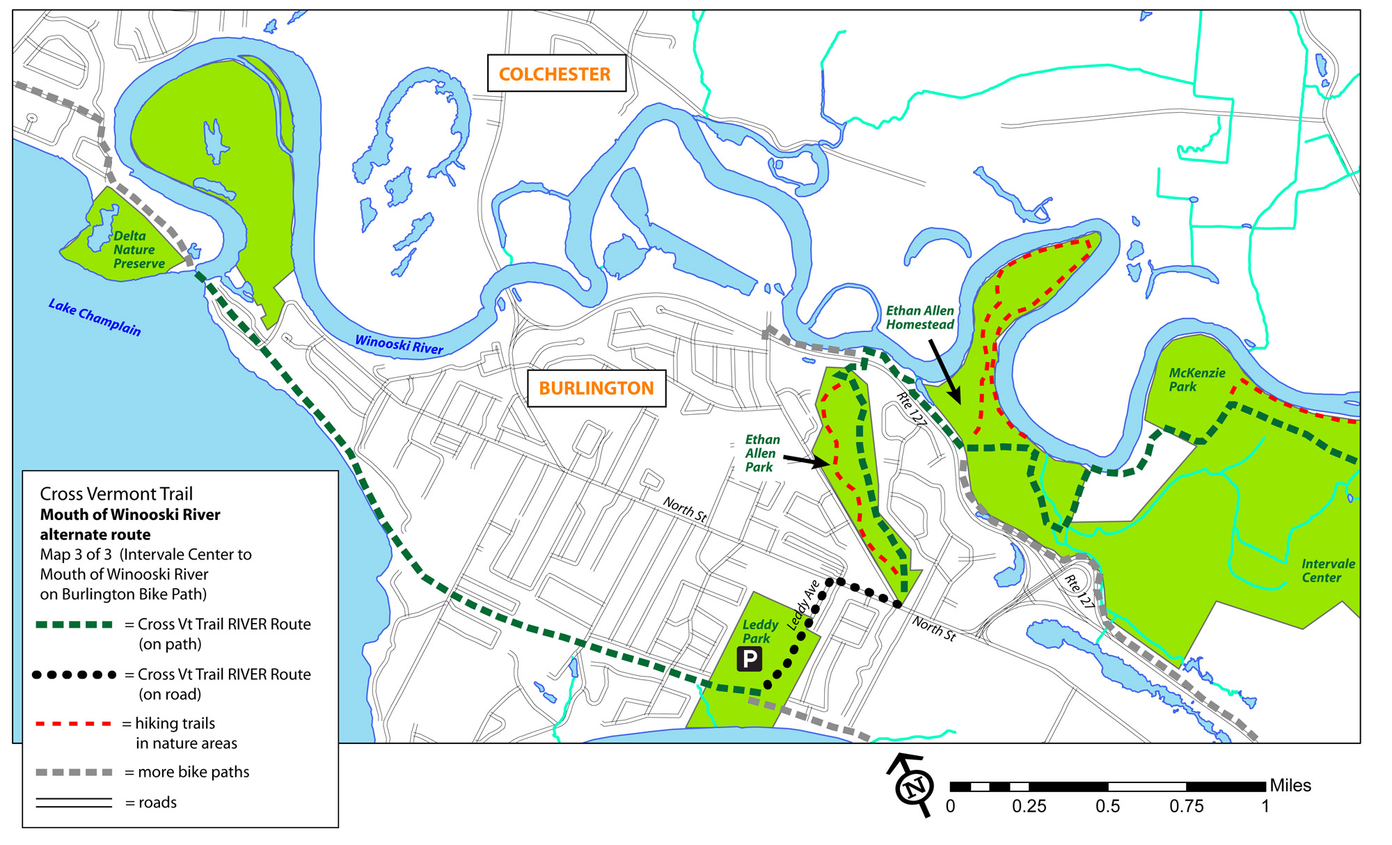
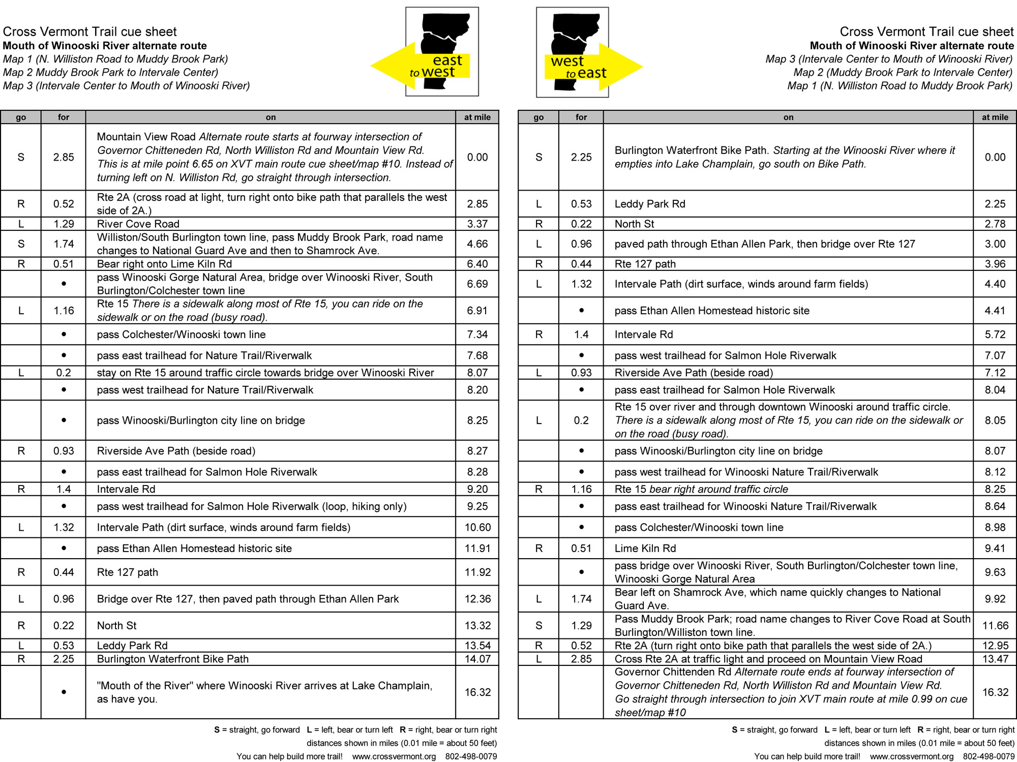
Alternate Route WILLISTON, COLCHESTER, WINOOSKI, BURLINGTON
Winooski River Route Williston (N. Williston Rd) to Burlington (Mouth of Winooski at Lake Champlain) (16.32 miles)
- Alternate route that more closely follows the Winooski River, and highlights a series of parks, nature conserves and trails along the river.
- These parks and trails are thanks to Winooski Valley Park District, City of Winooski, City of Burlington, Intervale Center, Burlington Wildways coalition, and many others.
- Three maps show the route, and one cue sheet; starting on Cross Vt Trail main route at west edge of Map 10, and then replacnig completely Maps 11 and 12.